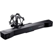
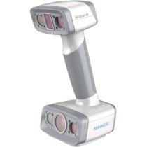
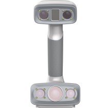
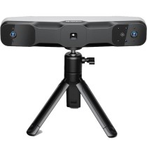
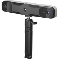
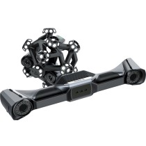
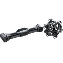
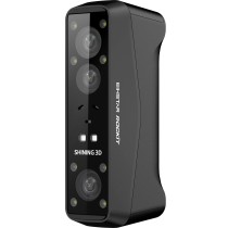
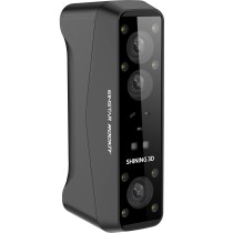
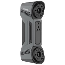
3Dmakerpro Raven LiDAR Scanner – Advanced Professional 3D Scanning Solution
The 3Dmakerpro Raven LiDAR Scanner is a next-generation handheld 3D scanning solution engineered for professionals who require a powerful combination of precision, speed, and portability in a single device. Designed to redefine large-scale spatial capture, Raven integrates cutting-edge LiDAR technology with advanced SLAM algorithms, high-resolution imaging systems, and intelligent data processing capabilities to deliver exceptional results across a wide range of industries. Whether you are working in architecture, construction, surveying, media production, or digital twin creation, Raven provides a reliable and efficient solution that transforms real-world environments into highly accurate and immersive digital models. Available in three configurations—Standard, Max, and Max RTK—this scanner is tailored to meet varying levels of professional requirements and project complexities.
Long-Range LiDAR Scanning Up to 100 Meters
One of the most impressive capabilities of the Raven LiDAR Scanner is its extended scanning range, reaching up to 100 meters, which significantly enhances its ability to capture large environments quickly and accurately. With an effective scanning radius of 40 to 50 meters depending on surface reflectivity, users can efficiently scan expansive spaces such as urban streets, industrial facilities, stadiums, tunnels, and natural landscapes without the need for multiple setups or repositioning. This extended range dramatically reduces scanning time while increasing operational efficiency, allowing professionals to complete projects faster and with fewer resources. The ability to cover large areas in a single workflow makes Raven an essential tool for high-demand projects where time and accuracy are critical.
High Accuracy and Reliable Data Capture
Accuracy is a fundamental requirement in professional 3D scanning, and the Raven LiDAR Scanner delivers exceptional precision with an accuracy of approximately 2 cm at 10 meters, maintaining stable performance across varying distances. Even at extended ranges, the device ensures reliable data capture, making it suitable for detailed engineering, surveying, and modeling applications. By combining LiDAR measurements with IMU data, image inputs, and optional GPS integration, Raven ensures accurate alignment of scans and minimizes cumulative errors. This multi-sensor fusion approach significantly reduces drift and improves the overall integrity of the captured data, resulting in high-quality point clouds that can be confidently used in professional workflows such as BIM, CAD modeling, and infrastructure planning.
Advanced SLAM Technology for Stable Scanning
The Raven LiDAR Scanner utilizes enhanced SLAM (Simultaneous Localization and Mapping) technology to provide a stable and seamless scanning experience, even in complex and dynamic environments. By intelligently integrating data from point clouds, camera systems, IMU sensors, and GPS signals, the system continuously validates and refines spatial positioning during operation. This significantly reduces the risk of misalignment and point cloud drift caused by operator movement or environmental factors. As a result, users can focus entirely on capturing data without worrying about maintaining perfect scanning techniques, making the workflow more efficient and user-friendly. This advanced SLAM capability ensures consistent and accurate results across both indoor and outdoor scanning scenarios.
Ultra-Wide Field of View for Maximum Coverage
With a 360° horizontal and 40° vertical field of view, the Raven LiDAR Scanner provides comprehensive coverage of the surrounding environment in a single pass, minimizing blind spots and reducing the need for repeated scans. This ultra-wide field of view ensures that both horizontal and vertical details are captured effectively, allowing for complete and reliable data acquisition in complex environments. Whether scanning confined indoor spaces or large outdoor areas, Raven ensures that no critical detail is missed. This capability not only improves data completeness but also significantly enhances workflow efficiency by reducing the time and effort required for multiple scanning passes.
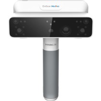
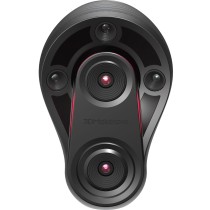
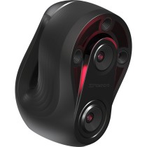
4K Ultra Imaging and True-Color Reconstruction
The Raven LiDAR Scanner is equipped with a high-performance 12MP camera system with a 1/2-inch sensor, capable of capturing stunning 4K true-color imagery that enhances the realism of 3D models. In the Max and Max RTK versions, dual camera systems further improve visual fidelity and color accuracy. The camera automatically adapts to varying lighting conditions, ensuring consistent performance in both indoor and outdoor environments. These high-quality images are seamlessly integrated with LiDAR data to generate RGB point clouds and advanced Gaussian Splatting scenes, delivering visually rich and immersive digital representations. This feature is particularly valuable for applications such as real estate visualization, virtual tours, and digital content creation.
Support for External 360 Cameras for Enhanced Visual Workflows
For users requiring even higher levels of visual detail and immersion, the Raven LiDAR Scanner supports integration with external 360-degree cameras, including popular models such as Insta360 X4 and X5. This capability allows users to capture panoramic imagery with greater coverage and resolution, significantly improving the quality of RGB point clouds and Gaussian Splatting outputs. By expanding the visual capture capabilities beyond the built-in camera system, Raven enables professionals to create more detailed and immersive 3D environments, making it an ideal solution for advanced visualization, cinematic production, and high-end virtual experiences.
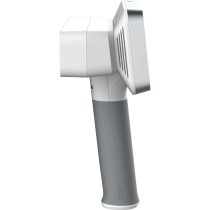
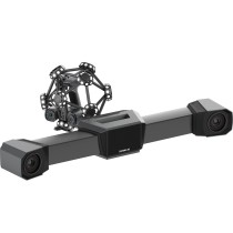
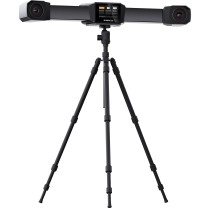
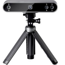
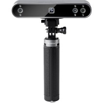
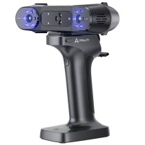
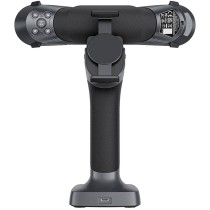
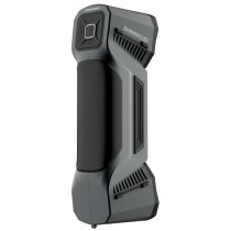
Lightweight and Portable Design for Field Applications
Weighing only 1.1 kg, the Raven LiDAR Scanner is designed with portability in mind, allowing users to carry and operate the device comfortably in a wide range of environments. Its compact and ergonomic design makes it easy to handle during extended scanning sessions, reducing operator fatigue while maintaining high performance. This lightweight form factor ensures that the scanner can be easily transported to remote locations, construction sites, or indoor environments without logistical challenges. Despite its compact size, Raven delivers powerful scanning capabilities, making it a perfect balance between mobility and performance.
Continuous Operation with Swappable Battery System
The Raven scanner features a high-capacity 12000mAh battery system that supports up to 2 hours of continuous operation, ensuring reliable performance during extended scanning sessions. The quick-swap battery design allows users to replace batteries instantly in the field without interrupting their workflow, making it ideal for time-sensitive projects. Additionally, the device supports external power input while charging, providing even greater flexibility for long-duration tasks. This continuous operation capability ensures that users can maintain productivity without downtime, even in demanding environments.
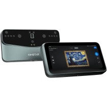
Powerful RayStudio Software for End-to-End Workflow
The Raven LiDAR Scanner is supported by RayStudio, a comprehensive software platform that enables users to manage the entire scanning workflow from data capture to final output. RayStudio offers advanced tools for processing, analyzing, and exporting point cloud data, ensuring that users can achieve professional-grade results with minimal effort. Features such as AI-powered denoising, automatic data optimization, and advanced visualization tools allow users to refine their scans quickly and efficiently. The software supports multiple industry-standard file formats, ensuring compatibility with CAD, BIM, and 3D modeling applications.
AI-Powered Optimization and Data Enhancement
RayStudio incorporates intelligent algorithms that automatically enhance point cloud quality by removing noise, optimizing data density, and improving surface accuracy. These AI-driven features significantly reduce the need for manual post-processing, saving time and increasing productivity. By delivering cleaner and more precise data, Raven ensures that users can achieve high-quality results suitable for professional applications without extensive editing. This level of automation makes the scanning process more efficient and accessible, even for complex projects.
JIMUMETA Platform for Hosting and Sharing 3D Content
The Raven ecosystem includes access to JIMUMETA, a powerful platform that allows users to upload, manage, and share their 3D content online. This platform supports advanced visualization formats such as panoramic tours and Gaussian Splatting, enabling users to present their work in immersive and interactive ways. Whether used for real estate marketing, architectural presentations, or digital exhibitions, JIMUMETA provides a flexible solution for showcasing 3D projects to clients and stakeholders.
Versatile Applications Across Multiple Industries
The Raven LiDAR Scanner is designed to support a wide range of professional applications. In architecture and construction, it enables accurate site documentation and BIM model creation. In real estate, it facilitates the development of high-quality digital twins for virtual tours and property marketing. In surveying and mapping, Raven provides detailed point cloud data for infrastructure analysis and planning. Additionally, it is widely used in media production, gaming, cultural heritage preservation, and forensic investigations, making it a versatile tool for modern digital workflows.
Expandable Ecosystem with Professional Accessories
Raven supports a comprehensive range of accessories that extend its functionality and adaptability. These include battery grips, RTK modules, 360 camera kits, backpack systems, bicycle mounts, automotive kits, and drone mounting solutions. This modular ecosystem allows users to customize their setup based on specific project requirements, enabling data capture in dynamic and challenging environments such as moving vehicles or aerial platforms. The flexibility offered by these accessories ensures that Raven can be adapted to virtually any scanning scenario.
Technical Specifications and Hardware Performance
The Raven LiDAR Scanner is powered by a robust 8-core 2.4GHz processor and equipped with 32GB onboard storage, ensuring smooth and efficient real-time data processing. It features a 3.9-inch AMOLED display for intuitive control and monitoring, along with Wi-Fi connectivity and USB Type-C interfaces for fast data transfer. With a point cloud generation rate of up to 150,000 points per second, Raven delivers high-density and detailed scanning results. It supports a wide range of output formats including LAS, PLY, OBJ, E57, and XYZ, ensuring compatibility with industry-standard software platforms.
3DRAYAN – Official Supplier in UAE
The 3Dmakerpro Raven LiDAR Scanner is available through 3DRAYAN.COM, a trusted supplier of professional 3D scanning solutions in the UAE. As an experienced provider of advanced 3D technologies, 3DRAYAN offers full technical support, consultation, and after-sales service to ensure customers achieve the best possible results from their investment. By choosing 3DRAYAN, customers gain access to reliable expertise and high-quality products tailored to professional needs.